OroraTech: How This Startup Is Extinguishing Wildfire Risks from Space

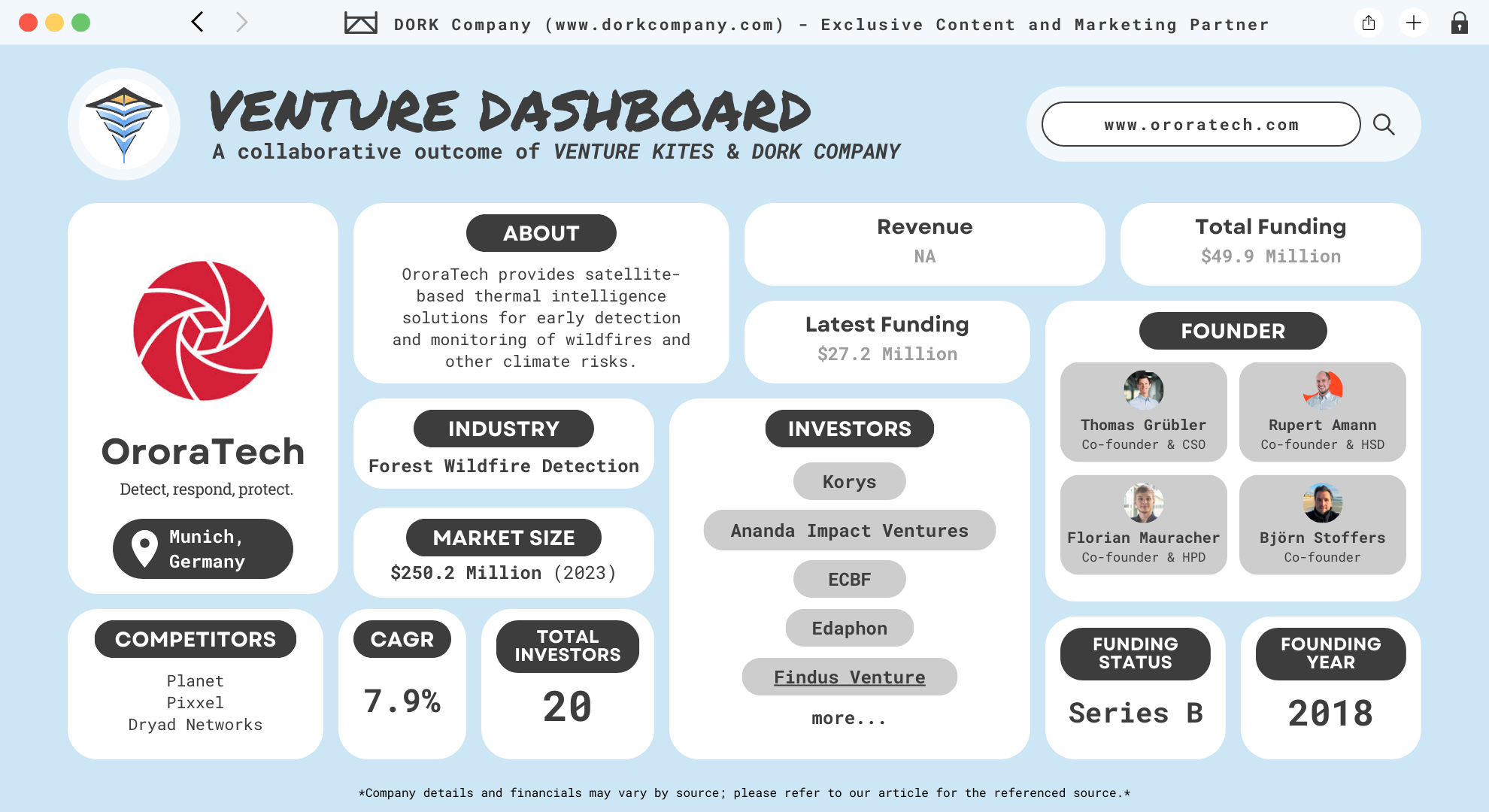
OroraTech is a German aerospace startup specializing in wildfire detection and monitoring through the use of nanosatellites. Founded in 2018 as a spin-off from the Technical University of Munich (TUM), the company is headquartered in Munich, Germany. The founding team comprises Thomas Grübler, Rupert Amann, Björn Stoffers, and Florian Mauracher. (Orara Tech)
Leveraging their academic backgrounds and expertise, they developed a system that employs thermal-infrared sensing technology to monitor Earth’s surface temperatures. This innovation enables the early detection of wildfires, allowing for prompt response and mitigation of potential damage.
What Does OroraTech Do?
Their flagship product is its Wildfire Detection and Monitoring Platform. This platform integrates data from over 20 satellite sources with advanced wildfire algorithms to provide real-time monitoring and early alerts for areas at risk. The service offers comprehensive features, including risk assessment, early detection, real-time monitoring, and damage analysis. These capabilities assist organizations worldwide in protecting assets and managing wildfire risks effectively.
By utilizing a constellation of nanosatellites equipped with thermal-infrared sensors, OroraTech delivers continuous global coverage. This approach ensures timely and accurate information, empowering better decision-making for clients across various sectors, including energy, infrastructure, insurance, and agriculture.
From TUM to Zooming Over Forests: Meet the Satellite Squad
OroraTech was founded in 2018 by four alumni of the Technical University of Munich (TUM): Thomas Grübler, Rupert Amann, Björn Stoffers, and Florian Mauracher. Their shared academic background and passion for space technology led them to establish a company focused on environmental monitoring through satellite technology.
Thomas Grübler, the CEO, holds a Master of Science in Electrical Engineering and Information Technology from TUM. Before co-founding OroraTech, he worked as a research engineer at fos4X GmbH, where he specialized in fiber optic sensors and silicon photonics. He also gained experience in graphical user interface development during his tenure at Magazino GmbH. (Thomas Grübler)
Rupert Amann serves as the Chief Technology Officer (CTO) of OroraTech. He brings extensive expertise in aerospace engineering and satellite technology, contributing significantly to the development of the company’s nanosatellite constellation. (Rupert Amann)
Björn Stoffers, the Chief Commercial Officer (CCO), has a background in economics and a strong interest in space technology. His role focuses on business development and expanding their market presence globally. Florian Mauracher, a co-founder and lead software engineer, plays a crucial role in developing the software platforms that process and analyze satellite data for wildfire detection. (Björn Stoffers)
The idea for OroraTech originated from the MOVE-II CubeSat project at TUM, where the founders collaborated on developing nanosatellite technology. Recognizing the potential of thermal-infrared imaging for environmental monitoring, they established OroraTech to provide real-time wildfire detection and monitoring services.
Since its inception, OroraTech has grown into a leading provider of thermal-infrared data intelligence, utilizing a constellation of nanosatellites to monitor Earth’s surface temperatures and detect wildfires early. The founders’ combined expertise in engineering, economics, and software development has been instrumental in the company’s success and ongoing innovation in satellite-based environmental monitoring.
A Hot Market: Fighting Fires and Fanning Innovation
The global forest wildfire detection system market is experiencing significant growth due to the increasing frequency and severity of wildfires worldwide. In 2023, the market was valued at approximately USD 250.2 million and is projected to reach USD 425.4 million by 2030, reflecting a compound annual growth rate (CAGR) of 7.9% during the forecast period. (Global Info Research)
This growth is driven by several factors, including climate change, which has led to prolonged droughts and higher temperatures, increasing the likelihood of wildfires. Technological advancements in satellite imaging, drones, and sensor networks have enhanced early detection capabilities, allowing for more effective monitoring and management of forest fires. Government initiatives and funding aimed at disaster management and environmental protection also contribute to the market’s expansion.
Regionally, North America dominates the market, accounting for over 40% of the global revenue, with a market size of USD 298.08 million in 2024. This region’s growth is attributed to the adoption of advanced technologies and stringent government regulations on wildfire management. Europe follows, holding a significant share due to similar factors. The Asia-Pacific region is expected to witness substantial growth, driven by increasing awareness and investments in wildfire detection systems. (Cognitive Market Research)
In terms of technology, satellite imaging stands out as a dominant segment, capturing more than 44% of the market’s revenue. Satellites provide comprehensive coverage and real-time data, making them indispensable for monitoring vast and often inaccessible terrains. The hardware component, including sensors and cameras, is projected to generate over 56% of the market’s revenue, highlighting the essential role of these devices in wildfire detection systems.
Mission: Imflammable – OroraTech’s Vision to Save the World
OroraTech’s mission is to revolutionize environmental monitoring and protection by providing real-time thermal intelligence from space. The company’s vision centers on leveraging advanced satellite technology to deliver actionable insights for mitigating natural disasters and managing resources effectively. (About Oraratech)
OroraTech addresses several critical environmental challenges, with a primary focus on early wildfire detection and monitoring. By utilizing a constellation of nanosatellites equipped with thermal-infrared sensors, they can detect temperature anomalies indicative of wildfires, enabling rapid response to prevent widespread damage. This capability is crucial for protecting ecosystems, human lives, and property from the devastating effects of uncontrolled fires. Additionally, their technology has applications in urban heat monitoring, agricultural irrigation management, and accurate carbon emission tracking, contributing to broader climate resilience efforts.
The company’s business model is built on providing real-time thermal data and analytics to a diverse clientele, including governmental agencies, forestry services, utility companies, and insurance firms. OroraTech offers subscription-based access to their Wildfire Detection & Monitoring Platform, which integrates data from over 25 satellite and ground sources. This platform delivers early alerts, live monitoring, risk assessments, and damage analyses, empowering users to make informed decisions regarding wildfire management and environmental protection.
Hot Tech: The Smokin’ Details of OroraTech’s Solutions
OroraTech combines cutting-edge satellite technology, advanced thermal imaging, and AI-driven analytics to deliver a range of innovative products and solutions. These offerings are meticulously designed to address critical challenges such as wildfire management, infrastructure protection, agricultural optimization, and risk assessment, all while promoting environmental sustainability.
Thermal Intelligence Platform
OroraTech’s Thermal Intelligence Platform enables precise monitoring of temperature anomalies worldwide, offering unmatched detection capabilities. (Thermal Intelligence)
- High Resolution: The system can detect anomalies as small as 4×4 meters, enabling early identification of potential risks such as wildfires, overheating infrastructure, or natural resource exploitation.
- Frequent Scanning: By 2026, OroraTech will achieve up to 48 scans per day, ensuring continuous and real-time global coverage.
- Rapid Data Delivery: Insights are transmitted within 3 minutes of detection, leveraging on-orbit AI processing to minimize latency.
- Calibration and Validation: The system employs scientific calibration to ensure accuracy, with resolutions down to 80 meters. It integrates seamlessly with external platforms such as Sentinel and Landsat for comparative analysis.
The platform is vital for applications in agriculture, infrastructure monitoring, and environmental conservation, providing actionable insights with unparalleled speed and accuracy.
Wildfire Detection and Monitoring
OroraTech’s wildfire detection solution is the pinnacle of satellite-based monitoring systems, designed to mitigate wildfire damage and reduce response times. (Wildfire)
- Advanced Detection:
- Detects wildfires as small as 4×4 meters using multi-spectral thermal imaging.
- Operates 24/7, regardless of lighting conditions, using both mid-wave infrared (MWIR) and long-wave infrared (LWIR) spectral bands.
- Provides precise location coordinates and area estimates of fires.
- Real-Time Alerts:
- Notifications delivered via SMS, email, in-app alerts, and WhatsApp within minutes of detection.
- Offers updates several times per hour, ensuring consistent monitoring of at-risk areas.
- Fire Propagation and Risk Analysis:
- AI-driven models analyze critical variables such as wind speed, humidity, fuel type, and topography to predict fire spread.
- Generates a 9-day fire danger forecast, helping users prepare for potential risks.
- Post-Fire Analysis:
- Delivers high-resolution burn area mapping and severity assessments.
- Tracks fire origin, evolution, and historical trends using automatic dashboards and visualizations.
This platform not only prevents large-scale destruction but also supports long-term wildfire risk management. It fuses data from over 25 satellites and ground sources, making it the most comprehensive wildfire detection system available.
Agriculture and Irrigation Management
OroraTech’s solutions provide essential data for smarter farming and sustainable agriculture practices.
- Water Efficiency:
- Monitors real-time temperature and soil moisture levels, enabling optimized irrigation.
- Saves up to 30% of water usage by tailoring insights to mid- and large-sized fields.
- Pest and Crop Management:
- Helps identify pest hotspots and monitor the impact of regenerative agricultural practices.
- Supports resilience to climate change with precise, actionable data.
- Frequency of Updates:
- Provides up to 48 daily scans, ensuring timely data for decision-making throughout the day.
This solution enables farmers to enhance productivity while minimizing resource usage, making it a critical tool for climate-smart agriculture.
Insurance and Risk Management
OroraTech’s data-driven solutions enhance the efficiency and reliability of insurance processes, particularly in wildfire-prone areas.
- Burn Area Detection:
- Identifies burnt areas within 24 hours using high-resolution thermal imaging.
- Offers precise post-fire loss estimates, accelerating claim validation and adjustment.
- Risk Assessment:
- Provides dynamic global fire hazard maps based on real-time and historical data.
- Supports risk-based pricing strategies for improved underwriting capabilities.
These capabilities extend beyond wildfires, supporting applications in agriculture, energy, and other high-risk industries.
Satellite Technology and Constellation
OroraTech’s satellite systems are at the heart of its technological innovation, employing state-of-the-art CubeSats for precise and cost-effective monitoring.
- CubeSat Design:
- Each satellite is compact, about the size of a shoebox, and flies in Low Earth Orbit (600 km altitude).
- Groups of 8 satellites per orbit provide full global coverage, with no risk of contributing to space debris as the satellites naturally deorbit over time.
- Thermal-Infrared Cameras:
- Equipped with mid-wave infrared (3.8 µm) and two long-wave infrared bands (8.7 µm and 11.45 µm).
- Cameras are capable of differentiating temperature with high accuracy, critical for detecting thermal anomalies.
- On-Orbit Processing:
- AI algorithms analyze data directly on the satellite, ensuring rapid insight delivery without relying on ground stations.
- Results are transmitted to the ground via satellite communication networks in seconds.
- Scalability:
- By 2025, OroraTech aims to launch a constellation of 8 satellites with a global 12-hour revisit rate.
- By 2026, the constellation will expand to over 100 satellites, providing a 30-minute revisit rate and sub-daily imaging of every location on Earth.
This robust satellite infrastructure supports applications in wildfire detection, urban heat monitoring, and agricultural planning, making it an invaluable tool for industries worldwide.
Geospatial Engineering and API Integration
OroraTech’s platform includes seamless integration options for businesses and governments.
- STAC-Compliant API:
- Allows easy integration into existing tools and workflows.
- Provides orthorectified and georeferenced data, ready for analysis.
- Customizable Solutions:
- Users can deploy custom detection algorithms on OroraTech’s satellites for specific use cases.
- Offers ArcGIS integration for advanced geospatial analysis.
These features ensure that clients can access and utilize high-quality data tailored to their operational needs.
Sparks of Genius: The Cutting-Edge Tech Behind Orora
OroraTech employs a multifaceted approach to wildfire detection and environmental monitoring, integrating advanced satellite technology, real-time data processing, and sophisticated software platforms. Central to their system is a constellation of nanosatellites, each approximately the size of a shoebox (10 cm x 10 cm x 34 cm), equipped with innovative thermal-infrared cameras. These cameras measure the temperature of each pixel, enabling the identification of thermal anomalies such as wildfires. (Technology)
A key innovation lies in the satellites’ on-orbit processing capabilities. By running AI-based algorithms directly on the satellite, OroraTech can detect fires and transmit alerts to the ground within minutes, significantly reducing latency compared to traditional systems that rely on ground station overpasses.
The data collected is integrated into OroraTech’s Wildfire Solution platform, which combines information from over 20 satellite sources. This platform provides users with early detection alerts, real-time monitoring, risk assessments, and damage analyses, facilitating informed decision-making for wildfire management.
OroraTech’s commitment to innovation is further demonstrated by their continuous expansion of the satellite constellation. The successful launch of FOREST-3 in January 2025 marked a significant milestone, enhancing their capacity to deliver near-real-time wildfire alerts globally.
Through the integration of cutting-edge satellite technology, real-time data processing, and comprehensive analytical platforms, OroraTech offers a robust solution for early wildfire detection and environmental monitoring, contributing significantly to global efforts in mitigating the impacts of climate change.
Burning Bright: OroraTech’s Impact and Recognition
OroraTech’s achievements include deploying the first thermal-infrared sensor, FOREST-1, in 2022, followed by the commercial launch of FOREST-2 in 2023. These milestones enabled real-time global coverage, delivering alerts within three minutes and detecting thermal anomalies as small as a single tree. Their wildfire solution is now trusted by organizations across six continents.
In recognition of their groundbreaking work, OroraTech has received several prestigious awards. In 2021, they won The Spark – German Digital Award, presented by Handelsblatt and McKinsey, which honors startups committed to climate neutrality and contributing to an emission-free future. (OroraTech)
Additionally, in 2024, OroraTech was selected as one of the top 20 finalists in the XPRIZE Wildfire Competition, highlighting their advanced capabilities in space-based wildfire detection and intelligence. With a strong presence in regions like California, Brazil, and Australia—areas most affected by wildfires—the company has saved millions in damages by enabling proactive action. (OroraTech)
In 2022, the company partnered with Rosenbauer, a leading manufacturer of firefighting equipment, to integrate satellite-derived thermal data into firefighting operations. This collaboration aims to provide real-time wildfire information to emergency responders, improving situational awareness and response times. (OroraTech)
In July 2022, OroraTech joined forces with EarthRanger, a data visualization and analysis platform used by conservationists worldwide. This partnership enables the integration of OroraTech’s wildfire detection data into EarthRanger’s system, assisting in the protection of wildlife and their habitats from the devastating effects of wildfires. (OroraTech)
Further expanding its collaborative efforts, OroraTech entered into a multi-year contract with the German Space Agency (DLR) in December 2024. This agreement provides DLR’s network of scientists and public authorities with access to OroraTech’s land surface temperature data, supporting various research and environmental monitoring initiatives. (SpaceWatch.GLOBAL)
Fueling the Flame: How OroraTech’s Finances Keep the Firefight Alive
As of October 2024, the company has raised a total of approximately $70.92 million over 13 funding rounds. The most recent funding round, a Series B, closed on October 15, 2024, raising $27.2 million. This round included notable institutional investors such as Korys, ECBF, Bayern Kapital, and Ananda Impact Ventures. Corporate backers included Edaphon, Findus Venture, and ConActivity, with IMAP acting as a facilitator. This significant funding aims to expand OroraTech’s global presence and enhance its predictive AI capabilities. (Tracxn)
Earlier in July 2024, OroraTech received a $21.5 million grant from the Ministry of Digital Governance. This prize money highlights the company’s recognition for advancing digital and environmental solutions on a large scale.
The Series A round, completed in two phases, raised a total of $22.6 million. The first phase, in November 2022, brought in $15.5 million. Key investors included Ananda Impact Ventures, Bayern Kapital, APEX Ventures, and SpaceTec Capital. Corporate participants like Edaphon, Findus Venture, the European Space Agency, and ConActivity also contributed, along with angel investors Clemens Kaiser and Ingo Baumann. The earlier phase, in June 2021, secured $7.1 million from similar backers, reflecting a continued vote of confidence in OroraTech’s growth potential.
OroraTech also received early-stage grants. In 2019, the European Union awarded $56,000, and the EIC Fund contributed $55,100 later that year. These grants provided critical support during the company’s formative years, enabling the development of its foundational satellite technology.
Fanning the Flames of Innovation: OroraTech’s Role in a Better Tomorrow
OroraTech is redefining how we detect and manage wildfires globally. They use nanosatellites equipped with thermal-infrared cameras to provide real-time wildfire detection. Their technology offers early alerts, live monitoring, risk assessment, and damage analysis, ensuring timely and informed decisions. By combining data from their satellites with other sources, OroraTech delivers unmatched precision and coverage, protecting forests, wildlife, and human communities from devastating wildfires.
The company’s innovation lies in its AI-based algorithms that process data directly in space. This reduces the delay between detection and action, making their system one of the fastest in the market. Their scalable satellite constellation allows them to monitor every part of the Earth multiple times daily. This real-time responsiveness is vital for organizations managing wildfire risks and environmental sustainability.
Through partnerships with organizations like the German Space Agency and EarthRanger, OroraTech enhances its global reach and impact. Their solutions have been adopted by firefighting agencies, conservation groups, and businesses worldwide, showcasing their effectiveness. With strong funding and continued innovation, OroraTech is scaling rapidly to address growing environmental challenges.
If you love reading about startups like OroraTech, check out other articles on Venture Kites. Explore more success stories, industry insights, and tips for entrepreneurs. Learn how to turn your ideas into impactful ventures.
At a Glance with DORK Company
Dive In with Venture Kites
Lessons From Orara Tech
Build a Global Vision from Day One
The Lesson & Why it Matters: Solutions for universal problems need global thinking. Building with this vision ensures scalability and relevance.
Implementation: Consider global applicability while designing your product. Research how different regions may need variations of your solution.
How OroraTech Implements It: Their nanosatellites monitor every part of the Earth, ensuring global impact in wildfire detection and prevention.
Push for Dual Benefits: Profit and Impact
The Lesson & Why it Matters: Businesses that balance profitability with societal or environmental impact often gain more trust and long-term success.
Implementation: Design solutions that address real problems while remaining profitable. Showcase the tangible impact you create.
How OroraTech Implements It: They help reduce wildfire damage costs while addressing the environmental impacts of climate change.
Build Resilience in Your Business Model
The Lesson & Why it Matters: Resilient business models withstand challenges like economic downturns or shifting regulations.
Implementation: Diversify your revenue streams and align your product with long-term needs to ensure sustainability.
How OroraTech Implements It: They serve multiple sectors, from governments to insurers, reducing dependency on a single market.
Focus on Speed Without Sacrificing Accuracy
The Lesson & Why it Matters: Fast solutions are critical in emergencies, but they must remain accurate to be effective.
Implementation: Balance speed and precision by integrating real-time data analytics and smart algorithms into your systems.
How OroraTech Implements It: They process data onboard satellites with AI, ensuring rapid yet reliable wildfire alerts within minutes.
Use Small-Scale Innovations for Big Impact
The Lesson & Why it Matters: Big problems don’t always need massive solutions. Small-scale innovations, if deployed smartly, can make a large impact.
Implementation: Break large problems into smaller, solvable parts. Focus on scalable innovations that grow as resources increase.
How OroraTech Implements It: Their nanosatellites are compact, cost-efficient, and scalable, yet they provide data that impacts entire ecosystems.
Youtube Shorts
Author Details
Creative Head – Mrs. Shemi K Kandoth
Content By Dork Company
Art & Designs By Dork Company