SatVu : Thermal Imaging Technology is Changing the Game from Space

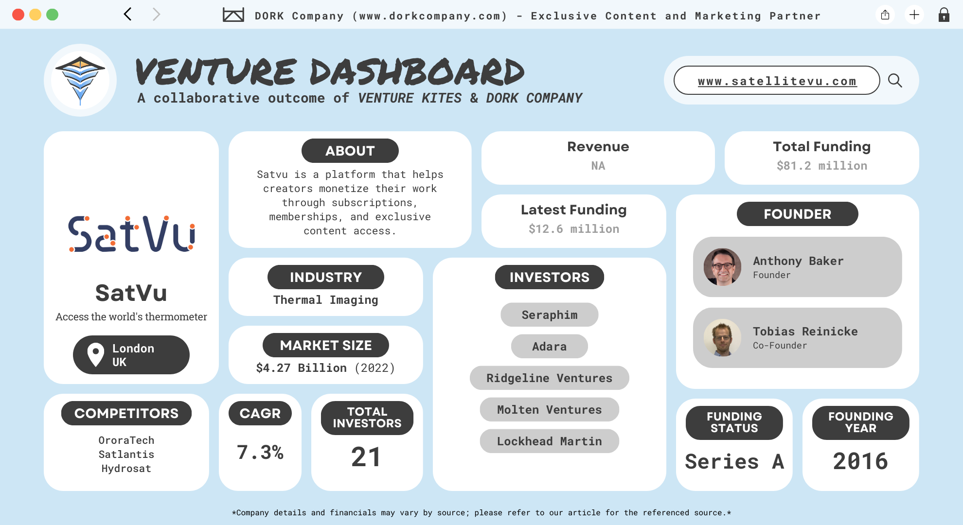
SatVu is a pioneering startup revolutionizing the thermal imaging and Earth observation industry. Founded in 2016 by Anthony Baker and Tobias Reinicke in the United Kingdom, the company specializes in delivering high-resolution thermal data from space to support climate resilience, energy efficiency, and security efforts globally. The startup is headquartered in London, where its innovative team works to bridge the gap between thermal technology and practical applications for industries worldwide.
SatVu stands out in the satellite imaging sector by focusing on thermal data, a critical but underutilized resource. Their advanced satellites, including the flagship HotSat series, provide 3.5-meter resolution thermal images. This level of precision enables detailed analysis of heat patterns, allowing users to monitor energy consumption, detect heat leaks, and assess environmental changes. Their technology is particularly valuable in addressing global challenges such as urban heat islands, industrial energy inefficiencies, and climate monitoring.
Unlike traditional imaging companies that focus on visible or multispectral data, SatVu has carved a unique niche by targeting heat signatures. This innovative approach has made it a key player in industries such as urban planning, national security, and environmental monitoring. By offering actionable insights derived from thermal data, SatVu empowers decision-makers with critical information to drive sustainability and efficiency.
Minds Behind the Vision: The Founders Bringing Earth a Thermometer
SatVu was founded in 2016 by Anthony Baker and Tobias Reinicke in the United Kingdom. Anthony Baker, serving as CEO, brings extensive experience in satellite technology and space exploration. With a career spanning over three decades, Anthony has held significant leadership roles in various prestigious organizations. Prior to founding SatVu in 2016, he served as the Chief Strategy Officer at Es’hailSat, the Qatar Satellite Company, where he was also a founding member of its senior management team.
Earlier in his career, Anthony was a Vice President at both SES and New Skies Satellites B.V., holding various roles focused on space development and capacity management. He also managed the engineering department at AsiaSat, demonstrating his hands-on expertise in the sector. Academically, Anthony holds a Master’s degree in Satellite Communications from the University of Surrey. Further, he completed the Sustainable Finance Foundation Course at the Smith School of Enterprise and the Environment, University of Oxford. (Anthony Baker)
Tobias Reinicke, the Chief Technology Officer (CTO), has a strong background in geospatial information systems (GIS) and computing. He earned a Master’s degree in Computing from Oxford Brookes University in 2006, following a degree in Geography and GIS from the same institution. Reinicke’s career includes roles as a GIS Developer at Oxford Retail Consultants, a GIS Technician at Eagle Technology, and a GIS Specialist at Astrium and Magellium. He also served as a Senior Technical Consultant at the Metropolitan Police, where he developed forensic tools and integrated GIS systems into incident management software. His expertise in GIS and data systems has been instrumental in developing SatVu’s high-resolution thermal imaging technology. (Tobias Reinicke)
The founding of SatVu was driven by a shared vision to create “the world’s thermometer,” utilizing space-based thermal imaging to monitor Earth’s temperature in near real-time. This innovative approach aims to provide valuable insights into economic activity, energy efficiency, and carbon footprints, supporting global efforts toward sustainability.
A Market on Fire: The Sizzling Growth of Thermal Imaging
The global thermal imaging market has experienced significant growth in recent years, driven by advancements in technology and expanding applications across various sectors. In 2022, the market was valued at approximately USD 4.27 billion and is projected to reach USD 7.59 billion by 2030, exhibiting a compound annual growth rate (CAGR) of 7.3% from 2023 to 2030. (Grand View Research)
This growth is largely attributed to the increasing demand for surveillance and security systems, particularly in the military and defense sectors. In 2022, the military and defense segment accounted for over 45.7% of the market share and is expected to grow at a CAGR of 7.7% during the forecast period. Thermal imaging technology is essential for operations in low-visibility environments, enhancing situational awareness and threat detection capabilities.
Beyond defense, the industrial sector is anticipated to experience significant growth, with a projected CAGR of 7.5% from 2023 to 2030. Industries such as manufacturing, oil and gas, and energy are increasingly adopting thermal imaging for monitoring and inspection purposes. The technology enables non-contact and non-destructive evaluation of equipment, facilitating early detection of faults and improving maintenance efficiency.
Geographically, North America dominated the market in 2022, accounting for over 32.2% of the global revenue. This dominance is due to the high demand for thermal imaging devices in law enforcement and the growing industrial and commercial sectors. Asia Pacific is expected to register the highest CAGR of 9.1% during the forecast period, driven by increased defense budgets and infrastructural developments in countries like China and India.
The COVID-19 pandemic has also influenced market dynamics, with thermal imaging technology being utilized for temperature screening in healthcare settings, airports, and public places to detect individuals with elevated body temperatures. This application has highlighted the versatility and importance of thermal imaging in public health and safety measures.
Keeping It Cool: SatVu’s Mission to Solve Hot Problems
Mission and Vision
SatVu’s mission is to capture the highest resolution thermal data from space for a safer and more sustainable Earth. By utilizing infrared technology, SatVu monitors locations on Earth in near real-time to measure the impact of human activity, providing valuable insights for applications ranging from economic monitoring and national security to climate resilience, including urban heat monitoring.
Problems They Solve
The company addresses several critical challenges. First, it enhances energy efficiency by identifying heat loss in buildings and infrastructure, enabling targeted improvements that reduce energy consumption and carbon emissions. Second, it supports climate resilience by monitoring urban heat islands and environmental changes, aiding in the development of strategies to mitigate heat-related issues. Third, it bolsters national security through surveillance capabilities that detect unusual thermal activities, contributing to threat assessment and disaster response. Additionally, SatVu’s technology assists in monitoring industrial activity and climate events, providing unique insights into phenomena such as wildfires.
Business Model
SatVu’s business model centers on deploying a constellation of thermal imaging satellites, known as the HotSat series, to capture high-resolution thermal data. The company then processes and analyzes this data to generate actionable insights, which are delivered to clients through a subscription-based platform. This approach ensures a steady revenue stream while providing clients with continuous access to up-to-date thermal imagery and analytics. SatVu collaborates with various organizations, including public, private, academic, and not-for-profit entities, to apply its technology in addressing some of the planet’s biggest climate challenges.
Tools of the Trade: SatVu’s Blazing Tech for a Better Tomorrow
SatVu delivers advanced thermal imaging solutions that empower governments, businesses, and organizations to make data-driven decisions across various sectors. By leveraging high-resolution thermal data, SatVu revolutionizes monitoring and analysis in national security, climate resilience, and economic activities. Below is an in-depth exploration of SatVu’s offerings.
Thermal Imagery: The Core Product
SatVu’s thermal imagery product delivers unprecedented resolution, precision, and adaptability, making it an indispensable tool for analyzing thermal activity. It uses mid-wave infrared (MWIR) satellite sensors capable of capturing data at a spatial resolution of 3.5 meters, providing a clear view of human and infrastructure activity.
Key Features:
- High Sensitivity: The system detects temperature variations as small as 2°C, enabling detailed analysis of operational patterns, infrastructure use, and environmental changes.
- Day and Night Imaging: SatVu’s sensors operate at wavelengths of 4.5–5 µm during the day and 3.7–5 µm at night, ensuring consistent data capture regardless of lighting conditions.
- Stacked Imagery: By combining multiple frames from a single observation, stacked imagery improves clarity, enhances signal-to-noise ratio, and provides a superior representation of the target area.
- Comprehensive Data Formats: SatVu provides data in Cloud Optimized GeoTIFF files, metadata in JSON format, and imagery previews in PNG format. These formats support integration into Geographic Information System (GIS) workflows.
Tasking Services
SatVu offers flexible and customizable tasking services, allowing clients to direct satellite operations for specific data collection needs. The tasking system is designed to deliver precise and timely results for a wide range of applications.
Tasking Options:
- Standard Tasking: Clients can define a date range for data capture.
- Assured Tasking: This premium service prioritizes the tasking request for a specific satellite pass, ensuring the highest level of service for time-sensitive operations.
Additional Features:
- Feasibility Checks: SatVu evaluates satellite position, orbital constraints, and weather conditions to ensure successful data collection.
- Catalog Withholding: Clients can specify a withholding period during which the captured data remains exclusive, preventing others from accessing the imagery.
Catalog Access
The SatVu catalog provides on-demand access to previously captured thermal data. Clients can search for available data, preview imagery, and estimate costs before placing an order. This feature is ideal for retrospective analyses and ongoing monitoring efforts.
Integration Capabilities:
- Access data through the SatVu Platform, a user-friendly web app.
- Automate workflows via RESTful API and Python SDK for seamless integration into custom systems.
Sector-Specific Applications
1. National Security SatVu empowers governments and defense agencies to monitor sensitive and strategic locations with unparalleled precision. Its high-resolution thermal imagery allows for comprehensive surveillance in both day and night conditions.
Key Use Cases:
- Nuclear Facilities: Monitor activity at nuclear sites, such as the Yongbyon Nuclear Scientific Research Center in North Korea, to assess operational patterns.
- Naval Bases: Track vessel movements and dock activity, even during nighttime or in adverse conditions like smoke.
- Airfields: Evaluate airfield capacity and detect operational trends at key locations.
2. Climate Resilience SatVu addresses the growing need for actionable data to combat climate challenges. By monitoring urban heat and environmental changes, SatVu supports sustainable development and disaster management.
Key Use Cases:
- Urban Heat Monitoring: Identify hotspots and assess the effectiveness of mitigation measures in cities.
- Wildfire Monitoring: Detect firefronts, hotspots, and movement patterns to support firefighting efforts.
- Deforestation: Track illegal and planned deforestation activities, helping to protect vulnerable ecosystems.
3. Economic Monitoring SatVu’s thermal imagery plays a vital role in analyzing infrastructure and industrial activities. It provides data to monitor productivity, track capacity, and optimize resource allocation across industries.
Key Use Cases:
- Power Stations: Infer operational capacity, output trends, and emissions.
- Oil Refineries: Monitor refining activity and assess efficiency down to the sub-plant level.
- Solar Farms: Detect faults in solar panels to enhance performance and reduce maintenance costs.
Advanced Technology Platform
SatVu’s platform is the backbone of its operations, providing clients with powerful tools to access, analyze, and act on thermal data.
Features:
- Global Reach: Unlike drones or aircraft-based thermal data collection, SatVu’s satellites capture imagery from anywhere on Earth, including restricted and inaccessible areas.
- Dynamic Imaging: SatVu offers video captures of up to 60 seconds, enabling users to monitor movement and changes in real-time.
Customizable Tools: Clients can integrate SatVu data into their systems using the RESTful API and Python SDK, enhancing their operational workflows.
Behind the Heat: How Their Cutting-Edge Tech Gets the Job Done
SatVu employs advanced space-based thermal imaging technology to capture high-resolution infrared data of Earth’s surface. Their system centers on the HotSat series satellites, designed to detect and measure thermal emissions with exceptional precision. These satellites operate in the mid-wave infrared (MWIR) spectrum, specifically within the 3.7 to 5 micrometer wavelength range, enabling them to capture detailed thermal imagery both day and night.
The HotSat-1 satellite, launched in June 2023, serves as the cornerstone of SatVu’s constellation. It features a high-resolution MWIR sensor capable of achieving a ground sample distance (GSD) of up to 3.5 meters at nadir. This resolution allows for the detection of temperature variations as small as 2 degrees Celsius, facilitating the identification of heat signatures from individual structures and activities.
To capture thermal data, HotSat-1 utilizes a sophisticated imaging system that records infrared radiation emitted from Earth’s surface. The satellite’s sensor array detects this radiation, converting it into digital signals that represent temperature variations across the observed area. These signals are then processed to generate thermal images, where different colors or shades correspond to varying temperatures.
One of the standout features of SatVu’s technology is its ability to capture thermal imagery at night and through smoke, conditions that often hinder traditional optical imaging systems. This capability is particularly valuable for applications such as monitoring industrial processes, assessing urban heat islands, and detecting wildfires, where visibility may be compromised.
Once the thermal data is captured, it is transmitted to ground stations for processing. SatVu employs advanced algorithms to calibrate and analyze the data, ensuring accuracy and reliability. The processed data is then made accessible to clients through the SatVu Platform, a web-based application that offers tools for viewing, analyzing, and downloading thermal imagery. Additionally, SatVu provides access via RESTful APIs and Python SDKs, allowing seamless integration into existing workflows and systems.
SatVu’s technology also includes tasking services, enabling clients to request specific data captures over areas of interest. Through the platform, users can define parameters such as location, time, and desired resolution. SatVu offers two levels of tasking: Standard Tasking, which schedules data collection within a specified date range, and Assured Tasking, which provides the highest priority with data capture on a specific date.
On Fire and Winning: SatVu’s Market Impact
SatVu has significantly impacted the Earth observation market by introducing high-resolution thermal imaging capabilities from space. Notably, in December 2020, they were chosen by Euroconsult as the 2020 FinSpace Top Tech Startup, a prestigious award that acknowledges the most promising and consequential tech startup in the satellite imagery and analytics industry. (Satellite Vu)
Following the launch of HotSat-1 in June 2023, which marked a significant milestone in capturing high-resolution thermal data, the company is preparing to launch HotSat-2 and HotSat-3, both expected to ship for launch in 2025. These satellites will enhance SatVu’s capacity to provide near real-time thermal data, essential for understanding energy transitions, monitoring infrastructure, and driving targeted actions toward climate mitigation and resilience. (Satellite Vu)
In June 2024, SatVu entered a multi-year strategic alliance with SUHORA, a leader in geospatial intelligence and AI solutions. This collaboration aims to provide spaceborne high-resolution thermal sensing and analytics tailored for defense, disaster management, and governmental organizations. (Suhora)
In September 2023, SatVu partnered with SkyWatch, a prominent remote sensing data technology company to make SatVu’s high-resolution thermal imagery available through SkyWatch’s EarthCache platform, enabling customers to access precision imagery for applications in climate monitoring, environmental analysis, industrial inspection, and defense intelligence. (Skywatch)
SatVu also collaborates with the European Space Agency (ESA) to advance its thermal imaging technology. In December 2024, ESA awarded SatVu a €1 million project grant to accelerate market readiness and scale operations in the energy sector. This partnership aligns with ESA’s Green Agenda, focusing on monitoring and understanding Earth’s changing environment. (Space Daily)
In August 2024, SatVu joined forces with the Office of Planetary Observations (OPO), an Australian nature data startup to enhance urban planning and greening initiatives by integrating SatVu’s high-resolution thermal data with OPO’s AI-powered Nature Data platform. The collaboration aims to provide evidence-based decision-making tools to better manage urban heat islands, assess the health of green spaces, and optimize tree planting strategies, contributing to more sustainable and resilient cities. (Satellite Evolution)
Burning Through the Numbers: SatVu’s Financial Journey
SatVu has secured substantial financial backing since its inception, raising a total of $81.2 million across six funding rounds. The backing from 21 institutional investors and corporate leaders like Lockheed Martin demonstrates the industry’s trust in SatVu’s vision. The company began its fundraising journey with a seed round in April 2021, securing $5 million. Institutional investors, including Seraphim and A/O PropTech, contributed to this initial round, providing the capital needed to develop SatVu’s early-stage satellite technology. (Tracxn)
In October 2021, SatVu raised $20.7 million in its first Series A funding round. This round saw participation from institutional investors such as Seraphim, A/O PropTech, E2MC, Molten Ventures, and the Earth Sciences Foundation. Additionally, corporate support from Stellar Solutions further bolstered this phase, enabling SatVu to expand its market reach.
March 2022 marked another milestone for SatVu, with the company raising $26.8 million in a subsequent Series A round. Seraphim remained a key institutional investor in this phase. In May 2023, SatVu raised $16.1 million in yet another Series A round. This phase included investments from Molten Ventures, Seraphim, Ridgeline Ventures, and A/O PropTech, along with corporate backing from Lockheed Martin. These funds were instrumental in the launch of SatVu’s first thermal imaging satellite, HotSat-1, in June 2023.
The most recent funding round took place in November 2024, where SatVu secured $12.6 million. This round featured a mix of institutional investors, such as Adara, Molten Ventures, and Seraphim, and corporate backing from Lockheed Martin. The capital raised will support the deployment of additional satellites in SatVu’s constellation, including HotSat-2 and HotSat-3, scheduled for 2025.
SatVu also received a grant of $1.4 million in November 2021, awarded by the Earth Sciences Foundation and the UK Government. This grant recognized the company’s innovative approach to thermal imaging and its potential to contribute to climate resilience and energy efficiency.
Smarter Heat Maps: Keeping the Planet Cool
SatVu is transforming the way we monitor and understand Earth’s thermal activities. By deploying advanced satellites like the HotSat series, the company provides high-resolution thermal imaging data that captures heat emissions with unprecedented precision. Their technology empowers industries, governments, and researchers to address challenges such as energy inefficiency, urban heat islands, and climate change.
What sets SatVu apart is its ability to deliver near real-time thermal data from space, enabling actionable insights across various sectors. From monitoring industrial operations to assessing environmental impacts, their innovative approach fills a critical gap in Earth observation. By offering solutions through an easy-to-use platform, SatVu ensures that its data is accessible and practical for decision-makers worldwide.
SatVu’s story is a testament to turning bold ideas into groundbreaking solutions. If you have an innovative idea, take action. Want to read more inspiring stories? Check out other articles on Venture Kites. Learn how startups across the globe are solving real-world problems.
At a Glance with DORK Company
Dive In with Venture Kites
Lessons From Laurus Bio
Plan for Long-Term Impact
The Lesson & Why it Matters: Companies that prioritize long-term goals create lasting value. They align their operations with a vision that extends beyond immediate profits.
Implementation: Build a roadmap with milestones that contribute to significant industry and societal impacts over time.
How SatVu Implements It: SatVu is scaling its satellite constellation to provide more frequent and global thermal imaging data for sustainable development.
Diversify Revenue Streams
The Lesson & Why it Matters: Relying on one revenue stream can limit growth. Diversification reduces risk and creates new opportunities.
Implementation: Develop multiple offerings around your core product to meet various customer needs.
How SatVu Implements It: They generate revenue through tasking services, historical data sales, and subscription-based access to thermal imagery.
Deliver Value Beyond Technology
The Lesson & Why it Matters: Customers value solutions, not just tools. It’s essential to provide outcomes that address their challenges.
Implementation: Focus on delivering comprehensive solutions that solve customer pain points, not just standalone products.
How SatVu Implements It: SatVu combines its thermal imagery with analytics and tasking services, offering actionable insights instead of raw data.
Stay Ahead by Specializing
The Lesson & Why it Matters: Specialization reduces competition and establishes expertise. A focused approach creates better products for a specific market.
Implementation: Define a clear niche and build unmatched expertise in that area. Avoid diluting your efforts.
How SatVu Implements It: They specialize in thermal imaging for Earth observation, offering unique solutions not available in traditional optical satellite imaging.
Prioritize Sustainability
The Lesson & Why it Matters: Sustainability is not just a responsibility; it is also a business advantage. Companies that focus on sustainability attract investors and customers.
Implementation: Incorporate sustainability into your core mission, operations, and solutions.
How SatVu Implements It: SatVu positions itself as a climate-tech company, using thermal imaging to promote energy efficiency and reduce carbon footprints.
Youtube Shorts
Author Details
Creative Head – Mrs. Shemi K Kandoth
Content By Dork Company
Art & Designs By Dork Company
Instagram Feed
X (Twitter) Feed
🚀 @satellitevu is revolutionizing thermal imaging from space! 🌍🔥
— Venture Kites (@VentureKites) February 11, 2025
They’re bringing real-time, high-resolution heat data to industries worldwide. Let’s dive into how SatVu is shaping the future of climate monitoring and sustainability. 👇👇#SatVu #ClimateTech #EarthObservation